Beyond the numbers: Mastering Laughlin/Bullhead International Airport (KIFP)

.avif)
From overhead, Laughlin/Bullhead International Airport doesn’t look intimidating, especially when compared to places like Telluride Regional and Aspen-Pitkin County. It sits low in the desert along the Colorado River, the runway stretches more than 8,500 feet, and the weather is often clear. Business jets, charter operations, air ambulances, and general aviation all funnel into what appears to be a straightforward approach.
Unlike Aspen or Telluride, altitude isn’t the main hazard here. At 700 feet MSL, it avoids the obvious “mountain airport” label. However, it consistently shows up on lists of challenging airports. Terrain rises quickly in most directions, summer heat sends the density altitude deep into hot-and-heavy territory, and departure performance can become a limiting factor.
This blog is the next in our Beyond the Numbers series. Shifting focus from alpine snow and thin air to desert heat, climb-gradient constraints, and rising terrain. It’s a reminder that high-risk airports aren’t always high-elevation airports.
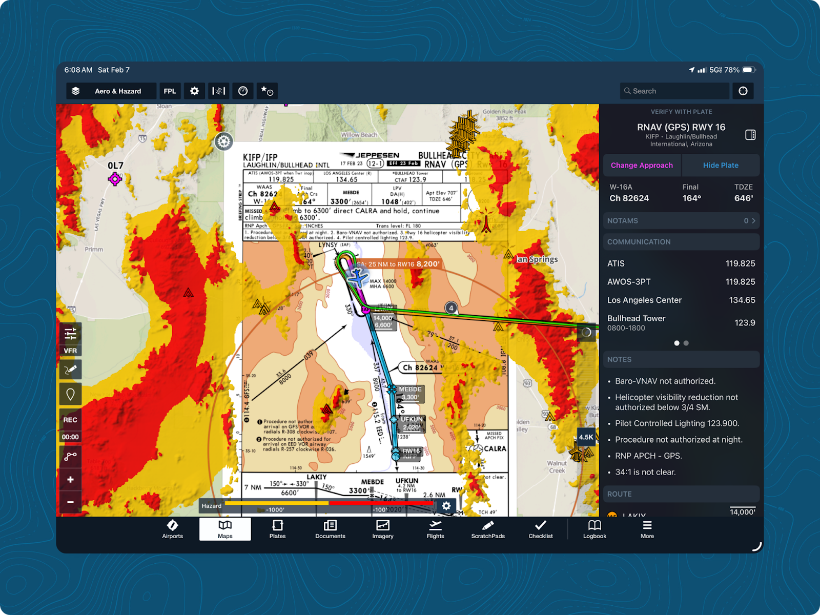
The field at a glance
Laughlin/Bullhead International Airport sits along the Colorado River, serving Bullhead City, Arizona, and Laughlin, Nevada. On paper, it looks simple. The airport itself typically isn’t the challenge. The surrounding terrain is.
Steep terrain from the Black and Newberry Mountains surrounds the airport from the north, west, and south. Only the southeast opens to flatter terrain, which heavily influences how arrivals, departures, and missed approaches are designed and flown. KIFP sees a mix of business, commercial, and general aviation traffic. The airport is Class D during the day and reverts to CTAF after hours.
Density altitude and terrain often dictate a preferred runway direction, regardless of wind. Convective activity, gusts, and river winds regularly require crews to balance crosswind components against climb performance and terrain clearance.
What makes Bullhead International challenging
Heat-driven density altitude
Summer temperatures in the Colorado River valley are often above 100°F (40°C). Despite the field’s low-elevation, density altitude can be similar to mid-elevation mountain airports. For turbine aircraft and heavily loaded piston twins, operations can feel hot and heavy.
Rapidly rising terrain
Terrain rises quickly on the north, south, and west of KIFP. The final approach path for runways 16 and 34 follow the river valley to stay clear of high ground, and even with standard straight-in minima, crews note how quickly the terrain rises near the final segment of the approach.
Mountain winds, turbulence, and downdrafts
Ridgelines and the river corridor produce turbulence, thermal activity from sun-heated slopes, and localized downdrafts. On hot afternoons, mountain winds funneling into the valley can cause sudden gusts and shifts near the approach end of the runway.
Visual environment and perception traps
At night or in reduced visibility, bright casino lights along the river can play tricks on depth perception and runway alignment. Pilots also tend to follow the river visually, which can lead to shallower-than-intended descent paths if vertical guidance isn’t followed carefully.
Current industry challenges
Fragmented performance tools
Many operators still separate routing, weather, and performance analysis into different tools. Even small changes, like hotter temperatures, shifting winds, or extra weight, can require recalculating takeoff and climb performance immediately. Switching between disconnected tools slows updates and increases the risk of inconsistent calculations between planning and the execution.
Static climb assumptions in a dynamic environment
Standard planning models use a baseline climb gradient or simplified obstacle-clearance assumptions. Terrain-driven procedures require aircraft-specific performance numbers that factor in forecast density altitude and winds at departure. Generic 200-ft/NM assumptions don’t account for localized downdrafts or reduced performance in 100°F (40°C) heat.
Dispatch and cockpit disconnection
When dispatchers and crews work from slightly different weather snapshots, they may unknowingly be planning two different versions of the same flight. Even a small discrepancy in planning can be dangerous, so having shared data in real-time is incredibly important for operational safety.
Time pressure
Bullhead International is a fairly busy airport, with many crews feeling pressure to maintain departure times and passenger schedules. Without a standardized system for performance calculations and clearly defined limits, time pressure can force crews to discount more conservative decision-making.
Bullhead International highlights a broader industry truth: when multiple variables move at once, manual workflows and siloed systems struggle to keep up.

Best practices for crews operating at KIFP
Plan for climb performance, not runway length
Calculate departure and missed-approach climb capability before considering runway length. Build conservative buffers for temperature, wind, and weight. If the climb margin is thin on paper, assume it will be even thinner in reality.
Time operations intentionally
In summer, early morning and late evening departures offer meaningful performance improvements. If operating mid-day, plan for reduced climb margins, lighter payloads, and increased turbulence along the river corridor.
Cross-check winds and weather
Use the most conservative wind component when recalculating performance. Conditions along the river can quickly change, especially during the hottest part of the day..
Keep planning and cockpit aligned
Ensure planning, dispatch, and flight crew are working from the same weather data, weight and balance, and performance assumptions in real-time. When conditions change, everyone should see the same updated calculations.
Crews should approach every departure with conservative margins, synchronized data, and clearly defined decision points. That discipline turns a high-risk airport into a controlled operation.
Mastering Bullhead International airport with ForeFlight Runway Analysis
Demand for high-traffic leisure destinations in business aviation continues to grow, and Laughlin/Bullhead International Airport is a frequent stop for many operators. Desert heat, rising terrain, gusty valley winds, and terrain-driven procedures test operational planning in ways that aren’t always obvious at first glance. Crews who operate here successfully pair disciplined decision-making with connected workflows and performance data they trust.
ForeFlight Runway Analysis is an integrated, real-time performance calculator that works with ForeFlight Mobile and Dispatch. By automating aircraft-specific calculations, validating climb requirements, and synchronizing updates across the entire operation, Runway Analysis provides clarity when heat, weight, and wind change at once. Instead of chasing numbers across disconnected systems, everyone works from the same calculations, under the same conditions, with the same assumptions.
Visit our website to learn more about ForeFlight Runway Analysis.

.jpg)