Beyond the Numbers: Mastering Toncontín Airport, Tegucigalpa (MHTG)


In December 2021, the last scheduled airline flight departed Toncontín Airport in Tegucigalpa, Honduras. The airlines had waited decades for an escape from one of the world's most demanding instrument procedures, and when Palmerola International Airport finally opened, they took it. But the mountain didn't go anywhere.
Toncontín is still there, still surrounded by terrain on every side, still serving business aviation traffic to the Honduran capital with the same short runway, the same low-altitude banked turn over a hilltop on short final, and the same unforgiving performance and planning considerations that made it famous.
What’s changed is who flies there.
Today, Toncontín is primarily a business aviation airport. While scheduled airline traffic has largely moved to Palmerola, operators flying into Tegucigalpa still face many of the same challenges that have defined operations there for decades.
This is the next blog in our Beyond the Numbers series. Tegucigalpa is not a story about a remote mountain strip or a seasonal challenge. It is a year-round, capital-city operation where aircraft performance, terrain, and crew precision all play a critical role.
The Setting: A Capital in a Bowl
Tegucigalpa, Honduras, is built into a valley in Central America’s highlands. The city sprawls across steep hillsides, and the airport sits just six kilometers from the city center, surrounded by ridgelines, residential neighborhoods, and terrain that towers above the runway.
At 3,307 feet MSL, Toncontín’s elevation is modest compared to airports like Engadin Airport in Switzerland. The challenge comes from the terrain. Published approach charts carry a standing caution: "High terrain all quadrants. Do not exceed the distance limit in basic procedure or holding." Even the published missed approach is a climb to 9,000 feet to clear the surrounding ridges.
The airport has a single runway 02/20, which extends 6,631 feet and slopes downhill by 1.14% when operating on Runway 02. That’s doable for most business jets under normal conditions. However, the displaced threshold on Runway 02 reduces the usable landing distance to 5,459 feet, while the missed approach requires aircraft to climb at 260 feet per nautical mile, or 4.3 degrees.
The Approach: What Makes Toncontín Unique
No other capital-city airport in the Western Hemisphere demands as much from a crew flying an approach as Toncontín does. A standard ILS final at a flat-terrain airport is a straight-line, stabilized, three-degree descent. Toncontín's terrain and airport layout make it that much more difficult.
The South Arrival: A Continuous Curving Descent
For most business jets landing at Toncontín, the preferred option, whether arriving from the north or south, is the RNP (AR) approach to Runway 02. The only difference is that aircraft coming from the south begin with a sweeping left turn through the valley to join the intermediate fix (IF). From there, the aircraft continues with a 90-degree turn around the surrounding terrain. Instead of a classic straight-in final, it’s a tight visual base leg. With less than 1.5 nautical miles to the runway threshold, there’s little time to line up.
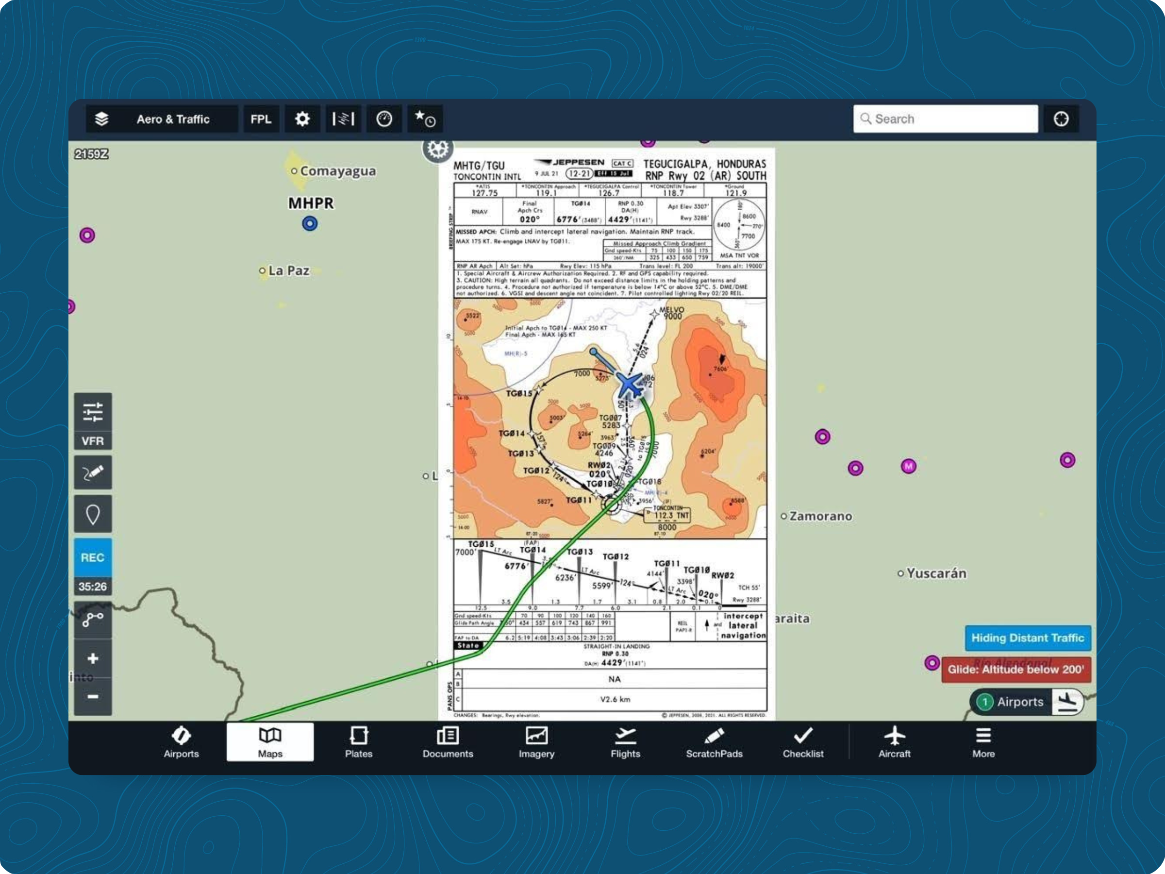
The procedure requires on-board navigation accuracy of 0.3 nautical miles, specialized aircraft certification, and a separate operator approval process. In terms of regulatory requirements, it's comparable to obtaining a CAT II ILS authorization.
If your crews and aircraft are authorized, the RNP AR approach is by far the best way into Toncontín. It was designed specifically for this terrain environment, guiding the aircraft through the valley on a protected flight path that would otherwise be difficult to achieve.
For those without the required authorization, things get more complicated.
The VOR/DME Approach: The Energy Problem
The VOR/DME approach to Runway 02 is the non-precision alternative. However, this procedure introduces several additional challenges. It places the aircraft on a straight-in final approach, but with a lot of terrain between the airplane and the airport. The Missed Approach Point (MAPt) is 1.7 nautical miles from the runway threshold, and the Minimum Descent Altitude is 5,620 feet MSL. With a runway at 3,307 feet, this would mathematically require an unviable descent profile from the MDA to the threshold. Because the MAPt defines the boundary of the missed approach rather than a normal visual descent point, crews must establish a strict Visual Descent Point (VDP) based on a stabilized approach path.
Since a standard 3° glidepath requires approximately 3 nautical miles of forward flight for every 1,000 feet of descent, overcoming a 2,300-foot altitude delta requires establishing a VDP roughly 7 nautical miles from the runway. That creates a practical limitation: although it is an IFR procedure, it requires visual acquisition of the runway well before the final descent. Well, it is an IFR approach procedure, but it is intended only to help you break through a possible cloud layer safely. In practical terms, the airport must be Ceiling and Visibility Unlimited (CAVU) VFR for you to land using this approach procedure.
But there’s a catch. You will never reach MDA 7 nautical miles from the runway because at 8.6 nm from it (7.0 nm from the VOR), your minimum altitude is 8,000 feet.
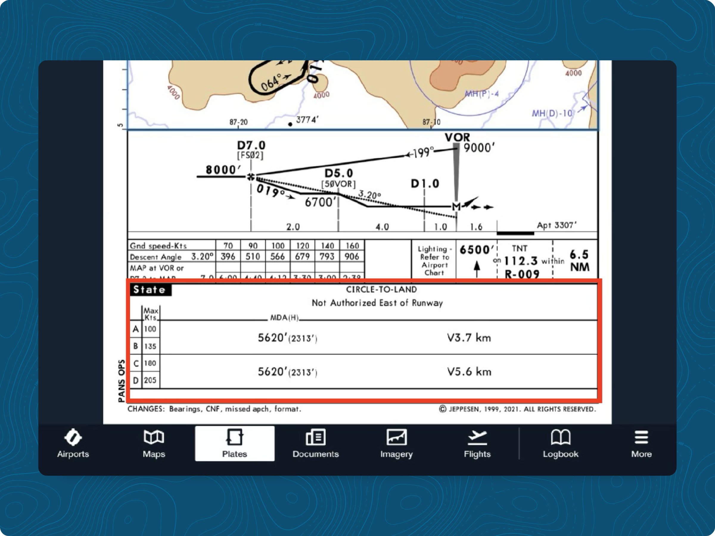
As shown in the highlighted part of the approach chart above, the procedure is a circle-to-land rather than a straight-in descent to Runway 02, as the plan view might suggest at first glance. Circle-to-land doesn’t mean it is mandatory to join the downwind leg. Continuing a straight-in approach on final is allowed, but only if the approach remains stabilized. In the event you choose to join the downwind leg to complete the circle-to-land, that doesn't necessarily make things easier. Terrain is still there, so the PAPI has to be set to 5.3 degrees, rather than the standard 3 degrees.
To give you an idea of how unlikely it is to continue straight-in to land on Runway 02, from MDA, if you follow the PAPI to land, you should start your descent about 4.2nm from the runway and 2.6nm before the TNT VOR. The problem with flying like that is that maintaining a constant airspeed on such a steep path forces the aircraft into an unusual attitude for this phase of flight. Nose down and thrust very close to idle. Although feasible, it is not exactly a model of a stabilized approach. To mitigate this, some operators may consider flying a tight base leg to avoid the hills and establish a standard 3-degree final approach path. While this technique is viable in daylight, attempting it at night removes essential visual terrain cues and significantly increases operational risk, so you will probably have to compromise and accept the PAPI’s steep-angle guidance.
And remember, after touchdown, you still have to stop. The 1.14% downhill slope of Runway 02 definitely will not help you to do that. So, be careful when planning your landing performance. Trying to land on a downhill, wet runway, maybe with some unpleasant tailwind, may very well lead to a runway overrun. And it has happened before.
In solid IMC, without RNP AR authorization, Runway 02 at Toncontín is not a viable destination.
The Turn Over the Hill
What passengers see, and what airport spotting videos have made iconic, is the final maneuver on visual approaches to Runway 02: a low-altitude, steeply banked left turn while descending past a hilltop that sits to the left of the approach path at 3,950 feet MSL, less than 1.4 nautical miles from the runway threshold and only 0.14 nautical miles left of centerline.
The mountain squalls and valley-channeled winds that accelerate across the approach path sometimes require immediate, aggressive control inputs at exactly the moment when the aircraft is low, slow, and in a bank. This is the operational margin that contributed to accidents in this airport's history.
Runway 20: Terrain on Final
For arrivals landing southbound, the RNP (AR) approach to Runway 20 presents an equally demanding terrain scenario. The approach procedure is flown inside a valley, and the pilot must adhere to the speed restrictions to guarantee the airplane will be able to stay on the intended track and never overshoot a turn.
The approach is also steep, with 3.5 degrees, but the turn to final is much smoother. There are lots of benefits of landing compared to the opposite threshold: the final waypoint leaves you almost lined up with the runway, DA is much lower (only 700 feet AFE), landing distance available is 6,631 feet with no displaced threshold, and after landing, the uphill slope helps you slow down the airplane much more easily. However, if you have to go missed, that brings a whole new problem.
The terrain rises rapidly in front of the runway, and you must make a right turn while climbing at least 260 feet per nautical mile (4.3%). It may not seem much, but on a hot day, if you are in a twin-engine aircraft climbing out with an engine failure, that number can be above your climbing capability.
The PAPI on this runway is also calibrated to a steep angle, just not as steep as Runway 02: 5.0 degrees instead of 5.3 degrees at the opposite threshold.
The same terrain that complicates the Runway 20 missed approach makes departing from it nearly impossible. An uphill roll followed by terrain rising fast ahead means Runway 20 is almost never used for takeoffs. If used, only VFR departures are allowed.
Departures: The Other Side of the Equation
Departures at Toncontín are discussed far less often than arrivals, but they carry equal weight in the performance equation.
The only published SID is an RNAV SID from Runway 02. The procedure requires climbing along a course through a series of fixes along a valley, with a very steep gradient requirement: 500 feet per nautical mile (8.2%), up to 12,000 feet. That is virtually impossible for piston-engine aircraft.
Even if you are flying a jet-engine aircraft, departing at maximum or near-maximum weight in warm, humid tropical conditions is a big challenge. Every crew must have an alternate engine-out departure plan. Performing that standard instrument departure might not be feasible in the event of an engine failure.
What the Accident Record Tells Us
Toncontín’s history includes several accidents that illustrate the challenges of operating at this airport.
In 2008, an Airbus A320 overran the runway by approximately 1,300 feet onto a public street after landing in conditions including a 14-knot tailwind, a wet, ungrooved runway surface, and an aircraft near its maximum landing weight. Five people died. The accident investigation identified the aircraft's weight, tailwind, and runway condition as compounding factors, each manageable individually, but collectively producing a stopping distance that the runway could not accommodate.
In 2018, a Gulfstream G200 charter flight from Texas overran the runway and ended in a ditch. The aircraft split in half. There were no fatalities, but the accident is a direct reminder that the Toncontín overrun problem is not exclusive to heavy commercial jets. It applies equally to business aircraft.
Across these events, the common denominator is energy management: too much speed at the wrong point, and no room to shed it. Toncontín does not forgive unstabilized energy states.
Best Practices for Toncontín Operations
Obtain and maintain RNP AR authorization before you need it. The VOR/DME procedure, while published, is operationally viable only in VMC conditions and deposits the aircraft in an energy situation that demands expert visual flying to resolve. For any operation that might encounter IMC, which at a tropical mountain airport with a rainy season means most of the year, RNP AR authorization is the practical entry requirement. This aircraft and operator qualification process takes time, and it cannot be done the night before the trip.
Plan landing performance conservatively, not optimistically. The usable landing distance on Runway 02 is 5,459 feet, and it must accommodate the energy of an aircraft that has just completed a steeply banked, rapidly descending final turn. The accident in 2008 involved an experienced crew, a familiar airport, and an aircraft that was within its certified limits on paper. Build margin into each factor, not just the worst-case scenario.
Brief the missed approach like a procedure, not a contingency. The missed approach at MHTG requires a climb to 9,000 feet MSL in terrain that rises above that altitude nearby. The OEI (one engine inoperative) case requires a specific operator-built procedure. For most aircraft, it is very unlikely they will be able to fly such a steep departure or missed approach in this condition. The published climb gradient requirements can become a hard performance constraint.
Use the published step-down altitudes as hard floors, not advisory references. At Toncontín, those altitudes exist to keep the aircraft above terrain. Deviating below them, even slightly, removes the protection they provide. Moreover, if able, avoid actually stepping down and leveling the aircraft. Although that was a common practice back when flying six-pack aircraft, modern systems can generate a continuous descent profile that respects all altitude constraints along the way. That will make your approach much more stable.
Coordinate fuel, ground handling, and permits well in advance. Toncontín does not require slots, but landing permits are required. Ground handling coordination with Tecnologias Unidas S.A. or AirSupport Group/CORPAV should be arranged ahead of departure. Jet fuel is available, but supply can be variable; advance coordination is recommended. Customs, immigration, and quarantine services are available on-field. Alternatively, leverage a comprehensive trip support service such as ForeFlight Trip Support.
Why ForeFlight Runway Analysis Matters at MHTG
It is not rare to see a crew jump into the airplane and just go. Takeoff and landing performance calculations are not exactly part of the routine of many pilots. That can be a fatal mistake when operating at airports such as Toncontín. Temperatures fluctuate, winds across the valley shift unpredictably, and the combination of a short effective runway, a steep approach with a late-stabilization geometry, and demanding climb requirements on missed approaches and departures creates a planning environment where there is no room for this kind of behavior.
ForeFlight Runway Analysis provides crews and planners with performance calculations tied to real-time conditions: current temperature, pressure altitude, wind, and aircraft weight. At an airport where the difference between a manageable approach and an overrun situation may come down to a 10-knot tailwind that showed up after departure, having numbers that reflect the actual flight conditions matters.
The tool is also able to provide engine-out departure analysis, where you can actually see in 3D the expected climb profile on a predetermined route, designed specifically to be flown in that kind of emergency.
.png)
The Missed Approach Climb Requirements feature addresses what has historically been the least-calculated variable in Toncontín operations: whether the aircraft, at its expected landing weight and in current conditions, can meet the published missed approach climb gradient. Knowing that before the descent begins, not at the missed approach point, is the operational difference between a go-around that solves the problem and one that creates a new one.
Runway Analysis, engine-out departure planning, operational landing distance required for landing, and missed approach climb gradients. ForeFlight is the whole package. With the right tool, flight planning has reached a new level. And that is the required level to operate safely at an airport like Toncontín.
Mastering Tegucigalpa and Beyond
The airlines left Toncontín because they couldn't grow. The approach stayed, the terrain stayed, and the operational demands stayed with them. For business and general aviation, this airport is now both the primary gateway to the Honduran capital and one of the most technically demanding pieces of airspace in the Western Hemisphere.
The operators who fly Toncontín safely are no more capable than others. They are more prepared. They have the required aircraft authorizations in hand before they depart. They have calculated the landing and the missed approach before they start the descent. They have built the weather window into the schedule rather than hoping for it. And they have treated the published procedures — every altitude, every step-down fix, every speed constraint — as the terrain protection they actually are.
That discipline is not optional at MHTG. It is how the approach is managed safely.
Click here to learn more about how ForeFlight Runway Analysis supports safe and confident operations at airports like Toncontín.

.jpg)